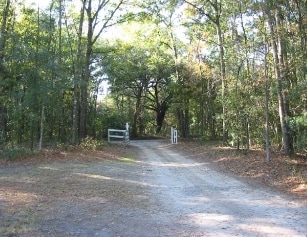
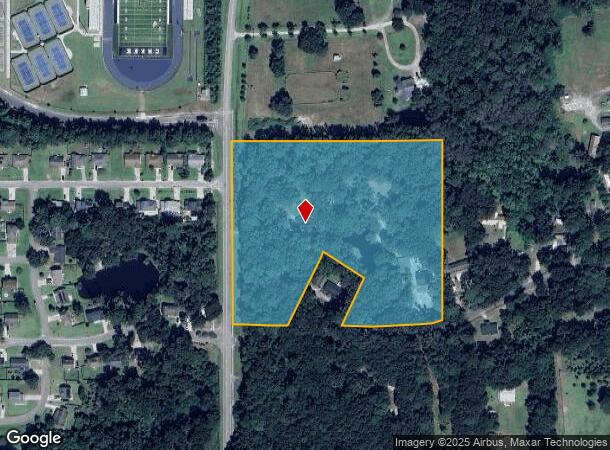
Property Record
54 Jennings Rd, Beaufort, SC 29906
NEARBY LISTINGS FOR SALE OR LEASE
Property Detail
54 Jennings Rd
Other Market Areas
Burton Commercial & Mixed Use
Hilton Head Island-Bluffton-Beaufort, SC
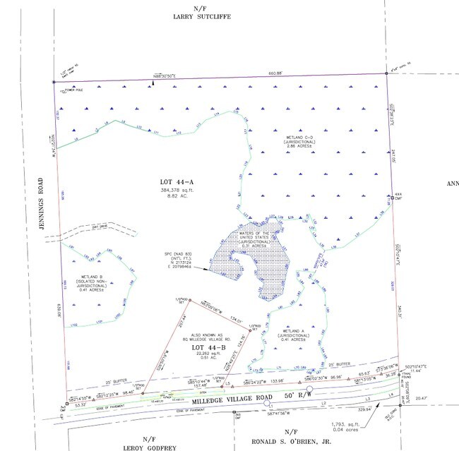
LOT 44-A SEC 3 1S2WPB25 P124 PB60 P166 PB71 P97*SPLIT 5/00 0.51 AC 28/329~02/2
R100-028-000-0038-0000
Beaufort
Institutionalgeneral
South Carolina
2025
44
2024
8.57 AC
000501
Hilton Head/Beaufort
DEMOGRAPHICS near 54 Jennings Rd
1 Mile
3 Mile
5 Mile
2024 Total Population
2,073
19,203
41,410
2029 Population
2,267
21,322
45,762
Pop Growth 2024-2029
+ 9.36%
+ 11.03%
+ 10.51%
Average Age
34
38
38
2024 Total Households
743
7,475
15,996
HH Growth 2024-2029
+ 9.02%
+ 10.66%
+ 10.52%
Median Household Inc
$44,150
$55,975
$56,940
Avg Household Size
2.70
2.50
2.40
2024 Avg HH Vehicles
2.00
2.00
2.00
Median Home Value
$144,285
$236,908
$254,673
Median Year Built
1988
1995
1990
Nearby Places
Map Layers
Map Styles
 Street
 Aerial
- Restaurants
- Banks
- Shops
- Fitness
- Groceries
PUBLIC TRANSPORTATION
AIRPORT
Hilton Head
DRIVE
WALK
Distance
Hilton Head
48 min
34.7 mi
Freight Ports
Georgia Ports - Savannah
DRIVE
WALK
Distance
Georgia Ports - Savannah
58 min
44.1 mi
Nearby Properties
Address
Land Use
TOTAL SIZE
Lot Size
Zoning
Address
Land Use
TOTAL SIZE
Lot Size
Zoning
4,613 AC
6601
Address
Land Use
TOTAL SIZE
Lot Size
Zoning
243,644 SF
13.23 AC
6601
Address
Land Use
TOTAL SIZE
Lot Size
Zoning
426,516 SF
32.63 AC
6601
Address
Land Use
TOTAL SIZE
Lot Size
Zoning
1,802 SF
21.42 AC
6111
Address
Land Use
TOTAL SIZE
Lot Size
Zoning
22,944 SF
16.59 AC
6101
Address
Land Use
TOTAL SIZE
Lot Size
Zoning
23,136 SF
9.67 AC
6101
Address
Land Use
TOTAL SIZE
Lot Size
Zoning
217,792 SF
60 AC
6611
Address
Land Use
TOTAL SIZE
Lot Size
Zoning
103,282 SF
19.22 AC
Address
Land Use
TOTAL SIZE
Lot Size
Zoning
85,656 SF
22.54 AC
6611
Address
Land Use
TOTAL SIZE
Lot Size
Zoning
39,296 SF
2.05 AC
6611
Address
Land Use
TOTAL SIZE
Lot Size
Zoning
24,024 SF
20.45 AC
6611
Address
Land Use
TOTAL SIZE
Lot Size
Zoning
142,753 SF
47.79 AC
6611
Address
Land Use
TOTAL SIZE
Lot Size
Zoning
214,795 SF
24.94 AC
6611
Address
Land Use
TOTAL SIZE
Lot Size
Zoning
60,814 SF
3 AC
Address
Land Use
TOTAL SIZE
Lot Size
Zoning
2,760 SF
4.16 AC
6611
Address
Land Use
TOTAL SIZE
Lot Size
Zoning
92,125 SF
10.14 AC
6611
Address
Land Use
TOTAL SIZE
Lot Size
Zoning
134,446 SF
19.90 AC
6611
Address
Land Use
TOTAL SIZE
Lot Size
Zoning
53,684 SF
24.30 AC
6611
Address
Land Use
TOTAL SIZE
Lot Size
Zoning
44,312 SF
1.87 AC
Address
Land Use
TOTAL SIZE
Lot Size
Zoning
52,322 SF
6.86 AC
6601
Address
Land Use
TOTAL SIZE
Lot Size
Zoning
20,800 SF
12.55 AC
6611
Address
Land Use
TOTAL SIZE
Lot Size
Zoning
53,704 SF
4.76 AC
6611
Address
Land Use
TOTAL SIZE
Lot Size
Zoning
32,035 SF
7.39 AC
4201
Address
Land Use
TOTAL SIZE
Lot Size
Zoning
192 SF
368 AC
6111
Address
Land Use
TOTAL SIZE
Lot Size
Zoning
73,938 SF
20.18 AC
4201
Address
Land Use
TOTAL SIZE
Lot Size
Zoning
85,127 SF
35.70 AC
6611
Address
Land Use
TOTAL SIZE
Lot Size
Zoning
17,432 SF
7.15 AC
6611
Address
Land Use
TOTAL SIZE
Lot Size
Zoning
5,990 SF
2 AC
Address
Land Use
TOTAL SIZE
Lot Size
Zoning
25,151 SF
6.41 AC
6601
The World's #1 Commercial Real Estate Marketplace
Connect with us
© 2025 CoStar Group
The information above has been obtained from sources believed reliable. While we do not doubt its accuracy we have not verified it and make no guarantee, warranty or representation about it. It is your responsibility to independently confirm its accuracy and completeness. Any projections, opinions, assumptions, or estimates used are for example only and do not represent the current or future performance of the property. The value of this transaction to you depends on tax and other factors which should be evaluated by your tax, financial, and legal advisors. You and your advisors should conduct a careful, independent investigation of the property to determine to your satisfaction the suitability of the property for your needs.